A New Way to Add Observations
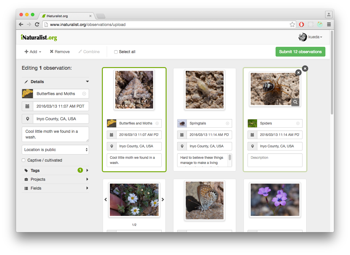
Adding observations to the website can be harder than it has to be, particularly when your photos contain so much useful information before you ever even upload them to the site. That's why we built http://www.inaturalist.org/observations/upload. The uploader makes it super easy to add observations to iNaturalist by allowing you to simply drag and drop photo files from your computer into the browser window, and then trying to extract as much information as possible from the photos themselves so you don't have to enter it manually. If you haven't tried it, give it a shot.
We released the new uploader a few weeks ago, but now we want to go one step further and make the uploader the primary way to add observations to the site. That means linking to the uploader instead of to http://www.inaturalist.org/observations/new, and perhaps even removing the latter way to add observations all together. We realize this will change the workflow for a lot of you, but we think the uploader is a better experience for almost all existing users, and a WAY better experience for new users.
However, we want to hear from you after you've tried out the new uploader. Are there things the old observation form does for you that the new uploader does not? Are there ways we can make the new uploader better before replacing the old observation form? Let us know in the comments below or in the Google Group.


Comments
This works for me, as long as I use the https URL. The http URL won't come up. I can cope, and it will make it a lot easier to add multiple observations from one place. Thanks!
Most of this works well for me except the map.
The majority of my obs are from Henderson Bay, NZ and when I put that it it defaults to 2991.886322 accuracy. I then drag the pointer to where I want it and with the old system the accuracy dissapears, but not with this new system so I have to adjust the accuracy also.
I also always use the full map which can not be done with this new system.
In the new system also, when I finally get the pin to where I want it, it changes the locality notes from Henderson Bay, New Zealand to Houhora 0484 (which is the area and not the place) so I have to change the locality notes back to what it should be. This does not happen with the old system.
I did a quick test to see if this is only for Henderson Bay NZ, but the same thing happens for all of the places up this way that I visit and have done observations from - the wide accuracy and the the changing of the location name from what is should be to what the maps think it is.
But the rest of it is great :)
Getting Google to give us data we can translate into coordinate accuracy has been tough. They've changed their API over the years, and the different ways they provide to turn place names like "Henderson Bay, NZ" into coordinates yield different kinds of results. We may be able to refine the behavior of the location search a bit, but sometimes we're just at the mercy of whatever service we're using for geocoding. That said, I think many consumers of iNat data would argue that anything that forces you to choose some level of accuracy is a good thing, since many scientists consider occurrence data to be unusable without that information.
Changing the "locality notes" was intentional, and we're certainly curious to here if anyone else cares about that. I was the only one on the team who thought even keeping that around was important, and what's there now was a compromise between my desire to control the text used to describe the location of my observation and everyone else's desire to show standardized place names.
I care about the locality! When I first started and didn't really know what I was doing I would put in Henderson Bay and keep the default. Then someone commented that all of my plants where in the ocean LOL so I then started moving the pin around.
I have just tested the locality again. If I use a suburb in Auckland city and move the pin it stays as the suburb, but if I put in Henderson Bay NZ (where the pin default is the middle of the ocean) then go and put it on land it changes the location to Houhora even though this place (and I live here) is called Henderson Bay, so changing to standardised place names will mean for rural areas like my place, the name is changed to the district.
This region where I live is an ecological hotspot for both endemic flora and fauna and there are many undescribed species here as well as a scientific reserve and the scientists may only get up here once or twice a year. Changing to standardised placenames will mean inaccurate data for scientists for anything found up here. I have already found new "northern limits" of plant species and as I can put in the place name then they know where it is.
A good example of how the standardised place names give inaccurate data is Ninety Mile Beach NZ (I have just tested that also). I found a new northern limit for a plant at the very northern end of the beach, but the standardised placename is Cape Reinga which is not where it was found. Another new northern limit I found out there standardises to Te Kao, which is a settlement inland and not on the beach. In fact the 6 stardardised names for Ninety Mile Beach are all inland except for 1. 90 Mile Beach is west coast and 1 of the stardardised names is even on the east coast!
In some obs (and not all of my own) I have been asked by scientists if I could gather a sample as I am the only member who lives in this remote ecological wonderland and to find obs that are not mine I need to know the real place name and not the stardardised one else I would never find what I was looking for, especially if the default location was used!
Anyway, for accuracy having the option to go to full sceen (which we currently have) would be great! Otherwise I admit I would get hoha sooner or later trying to move the pin around in that small window and then just use the default (with the 2.9k accuracy) for everything :D
Thank you for your time and work - it is appreciated :)
I like it the way it is. I would not change to this format. I find it perfectly easy to add my sightings. Please don't force me to stop using the current format.
"Upload" did not correctly find a township; the map went to a city of the same name. "New" (which is the old way) puts the pin in the township I searched for.
I do not see a way to save and add another observation, which is handy if I have several observations from the same area around the same time.
I have no idea what the box on the left is for.
Oh, yes, and it's annoying that the "upload" changes the location name.
I can't get it to work. Tried uploading two photos, and associated information. The thing is hung on "loading metadata". Forever.
Safari 6.2.8.
Folks, if you're having trouble uploading particular image files, please email them to help@inaturalist.org so we can test them out, along with a detail description of what you're expecting to happen and what actually happened. Screenshots are also enormously helpful.
I tried choosing some projects for a test observation, and it first added two of them, then everything disappeared. I mean, all the information I had entered got erased, and the entry boxes all vanished.
Also, if you choose a field, and you choose the wrong one , you have to throw the whole observation away and start over. There is no mechanism for correcting errors.
This thing needs a lot of revision. Please do not replace the current mechanism, which DOES work.
I also care about the locality! Standardized place names can go jump. Google Maps is fantastic but isn't God and is only as good as the assemblage of location data gleaned from other sources by engineers laboring under the arbitrary demands of a rotating assortment of PMs. Someone adding a custom-location observation to iNat is someone who has physically been in that exact place, and they're going to be in a heck of a lot better position to judge which particular beach/bay/town/reserve they were actually in, and what level of detail is informative.
yeah please continue to retain the mapping of locational uncertainty and allow for custom mapping. I use inaturalist for science and policy making and if someone does not have a locational uncertainty the mapping is nearly useless to me. And, ability to adjust location is vital to me for cases such as taking a photo of something from afar and adjusting it. That being said, for anyone who is not a mapping pro, it's better to use GPS either through the app or along with your camera.
Google maps definitely has some issues with uncertainty and location. For instance Eaton Canyon my favorite.
Not that anyone is proposing removing these features but still wanted to weigh in :)
I care about retaining the locality names I enter! I use them in several important ways. In fact, I'd like the option to enter a location name in the app, without overriding the coordinates and location info pulled from the photo -- I can do this for observations uploaded via the website but can't do it in the app.
I'm an ecologist, so I get the need for locational uncertainty, but in my experience, it's difficult and sometimes impossible to work with uncertainty values that aren't meaningful. There's no actual measure of locational uncertainty in the photo metadata, right? So anything else is arbitrary at worst, rough at best. That said, I've been making the effort (if somewhat inconsistently) to add locational uncertainty to my observations, and I can understand that 50 m versus 1 km matters, so rough distinctions can be useful. I'm not opposed to uncertainty being added automatically, but I don't want to have to adjust it down from a huge default every time I make an observation.
Related aside: It would be great to have non-circular options for locational uncertainty (is that a pipe dream?) -- the uncertainty is often linear/elliptical for my observations.
Somewhat unrelated aside: Are you all aware that even if one specifies obscured or private coordinates for an observation, the location (down to the address) is still displayed in the Dashboard of any followers? Is it possible to fix this? Not sure, but I think that entering my own location name gets around this (and this can't be done via the app, which is one of the reasons I'd like to be able to enter my own location name in the app, without overriding the coordinates pulled from the photo).
P.S. I love the new uploader! But am still exploring it and agree with others above not to delete the old method just yet.
hmm...
I myself haven't used the locality name for anything ever. That doesn't mean you can use them. But for things like site names I have been using tags. That works better for me. adding places is another option. This isn't to say you should do it how i do it, but just something you could try.
if you use one of the apps, the uncertainty data is from the actual phone GPS and is pretty good. If you import from a photo later, it unfortunately does not work. If you map manually you can add it. I agree that a completely useless uncertainty buffer is worse than nothing, but even still it is so important for mapping like i do that a little prodding to get people to use it is very worth the tiny inconvenience. Though there are probably good and bad ways to do that.
As for the locational uncertainty, it should NOT display anything beyond county or so. Are you looking while still logged in? When I look at this obscured observation while logged out: http://www.inaturalist.org/observations/3494039 I see only county level (not sure how that works in other countries). When I look when logged into me it has a street name and such. If you are seeing an address on an obscured location when looking out it is a bug and needs to be reported!
Frankly, I'm horrified at the new upload format.
First of all, since I am most often uploading multiple images for the same observation (especially for plants, moths, etc.), batch uploading of single images for multiple observations simply goes "cross-wise" to my standard upload protocol. With the new upload, apparently I would be required to upload just a single image to establish an observation, then re-open the observation to add additional photos--making this a two-step process where it is presently just one step. How would the new format allow for uploading multiple images per observation?
Secondly, I concur with those saying "standardized place names can go jump". I think it is critical to allow user flexibility to name a locality. At present, iNat thereafter tags an observation with "Places" in which the observation has been located. That's fine. Changing to automatic infill of placenames gets to both the ignorance/inaccuracy of Google Maps for local placenames, and issues of localization and privacy. With the present upload set-up, I can name a location and, if/when the map can't place it, I can then relocate the dot and accuracy manually in two simple fields. With the new upload, the interaction of automated placenames and the map and accuracy fields is clunky and not intuitive (to me).
Third, the new upload filled in "Tags" from my "Keywords" field in iPhoto (9.6.1). Yet my personal keywords may or may not (and probably won't) reflect tags that I would choose to place on an iNat observation. Since my keyword structure (for 50,000 photos and counting) is not going to be changed to make it seemless with iNat, I would have to manually remove or edit the tags on the iNat observation--thus again adding an extra and annoying step to the process.
I'll give the new upload format a few more tries but my initial feel for it is a big thumbs down.
I just uploaded 8 observations, some with two photos and it worked fine for me. Just drag you additional photo of the observation into the first photo and it works fine that way. I like that it saved my location each time, just had to click on the photo on the map. Adding the observations to projects was interesting, since they didn't all show up, but typing the missing ones in worked fine. This was faster for me. I'm using firefox and https URL.
Thanks for the tip on uploading multiple photos for the same observation -- that's a feature I've wanted when using the upload "From Photos" option, and I'll try it with the new uploader.
Also glad to know that the app can pull uncertainty from the phone GPS...unfortunately, I upload mostly via the website, though, for various reasons.
Don't want to hijack this post about a separate issue, but @charlie, the locational privacy issue I'm referring to is this: For anyone I follow, when she/he posts several observations with location obscured or private, the actual locations, down to the address and/or coordinates, are listed beneath the set of observations in my dashboard. So I have to assume that this is occurring with others for my obscured/private observations as well. For example, if my husband uses the app (and probably also the website) to upload observations made at our home address, even if he has made the location obscured or private, our home address will display underneath his observations in my dashboard (e.g., "See whiteoak's observations from {FULL ADDRESS}...")! When I go to individual observations, the location is obscured or blocked, but the location information is still right there on my dashboard. If I upload obscured or private observations via the website and enter my own location name (e.g., "Chatham County", but not otherwise overriding the coordinates pulled from the photo), I think it gets around this issue, but I'm not really sure of that.
P.S. Yes, for the other reasons that I use locality names, tags might be a good option -- just noticed that recently, and thanks for the reminder. The option to create locations is great for some purposes, but can be problematic for others -- e.g., once a location is created, then everyone who ever makes an observation in the area I define would have the location I created listed in the location information for their observations (this just happened recently with a location my husband created for a class project).
@jtuttle wow I did not realize that. Yeah, that needs to be fixed ASAP. @kueda @pleary are you aware of this? if this is true I'm kind of dismayed that my address was being sent to anyone who 'followed' me... not a huge deal, but certainly not optimal. For other things like obscured observations it would be a bigger deal.
As for the places.. .i think a 'private places' feature would help a lot with that among other things. For instance someone (Rachel?) mapped most of the San Bernardino Mountains as 'rachel's area' and then stopped using inaturalist and now all my observations from there say they are in Rachel's area.
@jtuttle i just checked what you said and it is true. Making an issue on github... needs to be fixed asap.
Guys, please focus on the uploader here. If you have other problems with things like geoprivacy, please open new threads in the Google Group. In general, I'd personally appreciate it if you all would try and explore this tool a bit before expressing your "horror", and keep in mind that some of the horrifying things might be problems we're just not aware of instead of conscious decisions. For example, @gcwarbler's concern about adding multiple images per observation is specifically one of problems we made this thing to address! I realize not all of the functionality is immediately obvious to everyone, but please try and think about what all the buttons do. In this case, you can drag on a bunch of photos, use your mouse to select ones that should all be one observation, and then click the "Combine" button to make them a single observation. Less obvious but even easier, you can just drag and drop the photos onto each other to combine them.
Regarding locality notes, again, please actually try this thing. They've been de-emphasized, but the functionality is pretty similar to the old functionality, i.e. you choose a location on the map via clicking or searching by place name, and if you want to be really specific about the place name (as I sometimes do), you can type it in and it should save. If it's getting overridden, then that's a bug we'd like to know about, but we haven't scrapped the custom locality names. The only real change is that changing the coordinates will change the locality notes. Maybe we should change that so custom locality is never over-written, but while I like entering a custom locality, I'm pretty sure 90% of people could care less. We're obviously not scrapping coordinate uncertainty so there's no need for tangents on that subject.
Reports above of information getting overwritten or blanked out sound bad, but there's little we can do to fix those problems unless you send the photos you're trying to upload to us at help@inaturalist.org. If we can't replicate your problem it's almost impossible to solve.
To respect that request and offer feedback: I mostly use the app but from what I've seen of the uploader so far I like the new one better than the old one.
After using the new uploader heavily over the past few weeks I really like it and haven't run into any problems. I used the old "from photos" uploader 90% of the time (mobile or Batch the other 10%), so the new version has been the same use-wise except for the new abilities. Being able to quickly combine photos into one observation makes the overall process so much faster and I super love it. Being able to add map location to batches of stuff from the upload page is also great and saves me trips to the Batch Edit screen.
I like it. This is especially good when you can drag a photo onto a photo and it becomes part of the same observation. I used to do imports in batches. It pains me to add photos to the same observation. Actually I have not been using the old "upload" method. I always use "import" where I can choose a list of observations from Picasa Web. The picture size is limited by Google. Now I can drag and drop observations in its original size. It is a real improvement for me.
On thing I would comment is the "Description". The old method understands that the "caption" of the picture is the description. It now takes "image description" as the description. May be it should check whether caption is empty before using "image description" or simply allow user to choose default setting. Some camera default its camera name as the "image description" and editors like Picasa allows caption editing only. Editing just a few is not a problem. At times I load hundreds of observations edited using Picasa. It is a real hassle to change all the description to caption.
I could never get drag and drop to work from Photos to Safari, but the new form did let me choose photos the way the old form did. But, it made a separate observation for each one, so I had to drag them to combine. One out of six observations continued to say "loading metadata" forever, so I had to add it the old way, delete it from the new form, and then it let me upload the five remaining. I received a message that some of the observations didn't get added to some of the Projects I specified, but there's no details, so I will have to go back to each observation individually and check those. Also, when you are choosing Projects, it should list those you've joined like the old form instead of every Project in iNat.
Like @sea-kangaroo I used the old Photo Uploader most of the time and am loving the new version, especially the ability to combine multiple photos into one observation. We all get into our specific workflows and a change to those can be frustrating, but I think with some exploration and patience we can adapt this to our old routines or even improve upon them. If not, specific feedback is being considered by the team.
@lauramorganclark and others, it looks like the "loading metadata" bug is being worked on at the moment: https://groups.google.com/d/msg/inaturalist/V4t3_W5YT7o/-9a3HVTAAgAJ
I, too, would like for it to only show all of my projects. It's tedious to type them in each time, and far easier just to add them after the observations are saved.
Also, today, when I typed in my location, clicked on it when it came up and hit save, it wouldn't save it the first time until I enlarged the map and pinpointed my location. All further observations did show location no problem.
I really like the new uploader. It let me add all the important information before hitting the submit button. I found it very easy to use, and very clear. Perfect to upload multiple pictures for each observation.
Thank you for keeping improving iNat!
I'm really loving the new uploader and using it a lot. When I used it a couple of weeks ago, I thought that it ordered my photos by the order in which I dragged them onto each other, but today I noticed that once uploaded, the images aren't showing up in the order I expected them to and I have to re-order them. Perhaps this changed with the most recent updates to the uploader?
@carrieseltzer I had the same problem with picture order. How did you reorder them without deleting and reuploading?
The order thing is something we took a stab at but it proved to be a bit difficult, so we're not going to address it before making this the primary way to add observations. I agree it's a bit frustrating when you need to drag a photo out of an observation, though.
Folks, we're hoping to make this the main way to add obs by the end of the week. We're going to keep http://inaturalist.org/observations/new around for a little while longer, particularly for projects, but we'll change the dashboard link and the header menu links to http://www.inaturalist.org/observations/upload.
We're looking into the mapping issues, and will make it so a custom "locality" description never gets overwritten by map interactions. Project selector only showing the projects you've joined is a bit trickier but we're investigating. The "Importing metadata" issues (disable submit button, images never uploading) should all be fixed. We have a few known bugs with parsing keywords into observation fields and manually-added tags disappearing that we're working on right now.
For those of you who reported issues with information disappearing, I still have not received the photos you were trying to upload at help@inaturalist.org so I can't replicate your issue. Until I can do so there's nothing we can do about those problems. @techieoldfox, it would also be helpful if you could email us some of the images you have where the "Caption" or "Image Description" metadata isn't getting parsed.
Thanks for the update, Ken-ichi. The order thing is annoying when the first photo I took isn't the one I want to show by default, since it seems to place first the first one taken.
@lauramorganclark it's hard to find, but if you "edit" an observation and then look under your photos on the right, there's a little link that says "re-order photos". You can also do it pretty easily on the app (or at least easily designate the default photo on the app).
So. What is this is giving me that i don't already have?
@carrieseltzer I see it, thanks so much. The new uploader is much faster for me, but I still can't drag and drop -- I still have to click on Choose Photos. No problem, though, as long as that remains an option.
Really enjoying this uploader, the combining photos, not having to type in a date etc. Also like being able to choose obs then put in a description for them without having to copy and paste.
When I first tested this I could put in Henderson Bay NZ and the map would adjust to there, now putting that in, or even Henderson Bay New Zealand will not zoom anywhere, only stay as the world map so now I have to manually zoom in. This however is not happening using the old system.
I've been trying to use the new upload page and I'm afraid I still don't like it. Here are some of my ongoing annoyances (from small to large) in it's present configuration:
The floating info balloons pop up too easily, block other fields, and stick around too long. I don't need/want them; the fields seem obvious to me. I'd rather see a discrete little "Info" button adjacent to each field. I just don't like uncalled-for floating info balloons.
The "Description" block is minute for my usual, verbose entries which often include explanatory text, ID discussion, and links to relevant pages on MPG, BG, etc. Even though it's a scrolling field, it reeeeally needs to be larger to visually facilitate the text editing we verbose iNatters need. The new format in its entirety seems geared towards iOS dimensions, taking up only the upper left quadrant of my (large) computer screen. Anyone/everyone using a desktop, laptop, or tablet for data entry will have more screen space; I'd prefer to see a more generous use of that space.
The automatic data fill for several fields is of almost no use to me. I almost invariably have to edit the ID, the Location, the Descripton, and the Tags? I can see that they'll be of some utility for some users, but not me. I'd rather start from a blank slate. Could you make autofill of fields an option rather than a SOP?
I much prefer to have all the info for a given record displayed for handy inspection, particularly the image, my description, and the map. That is a great advantage of the current upload format. The small collapsing fields of the new upload format leave me clicking here and there to see what I've entered. It's like playing "whack-a-mole" with the entry fields.
Keep working on the Projects field. I need to immediately see a list of my projects...perhaps in the order of my most recent use. The autofill Projects search is just too tedious. I'd rather see my list and click on an "Add" button as it presently works.
I belong to a set of iNatters (a silent majority??) that don't typically upload multiple observations at once. Maybe a subset/selection of power users do. I don't. My uploads are each individualized, thoughtful, carefully edited offerings...and I enjoy this process. The new upload format seems to favor or be geared towards multiple uploads. This is simply of no use to my standard entry protocol for iNaturalist. I find it discouraging and disappointing to think that the new format will be made standard for all users.
I've said my piece/peace.
I don't want to just dump this stuff in the cloud as fast as possible…... so that it then becomes somebody else's problem.
I do what GC does. I expend effort on each and every post. I upload my list of files, then i reorder them carefully to display IDable features as needed, i edit fields that enlighten organism characteristics and perhaps assist ID. I put in informative links and remarks, and if appropriate i link observations to one another. These operations take time and spending time is what makes this stuff valuable.Lastly, I add the observation into one or more projects, and for me that is the most essential part of the enterprise.
Chuck, thanks for sticking with it. While I suspect you and Ellen and others who dislike this new interface are in the silent majority of users who only add a few observations at a time, I can pretty much guarantee you're in a tiny minority of users that are as meticulous and verbose in the way they craft their observations as you are, so as much as I wish the opposite were true, I don't think your use case is typical. I realize that level of craftsmanship is both satisfying and, ultimately, the most valuable and educational way to record this kind of information, but we've watched a lot of people using our software, and one overriding truth is that most people hate, hate filling in forms. Just seeing a form is often enough to make a new user give up. "Like homework" is usually the dismissive description we get, though "like taxes" would be equally apt. That goes a little ways toward explaining the de-emphasis on form fields, and why automatically filling those fields is critical and helpful for most people.
Have you thought about using the uploader as just a step in the process and not your final touch on your observations? E.g. you could upload what you intend to upload, combine your images, submit them, and then edit each observation and devote the same attention to detail you did before, with exactly the same interface as before. I'm guessing you'd be dissatisfied with letting an "unfinished" observation hang out on the web while you're still editing it, but does that really matter if what's important to you is the value of that process for your own self-education? My personal philosophy is that I generally prefer to get things out there for others to discuss than postpone upload indefinitely because I want it to look like my best effort. I'll continue to pour more time into the things I care about (e.g. moths), but I'm generally happy to just throw other things up there because I know others might enjoy identifying them more than I will.
I totally hear you about the annoying tooltips and the projects selector. We're working on the projects thing, and I think we need to rethink the tooltips. @tangatawhenua, we're hoping to have a fix for your location issues out shortly.
please don't make this change mandatory. I have worked out my method here. It is time consuming but it works great for me. I upload through a link to Picasa and do one observation at a time.
hmm... is there a reason to make it mandatory? Does it cost more or cause problems for the devs to leave the old method available? You could even unlink it and just keep it there for those who prefer it. There are plenty of other things like that, right?
I like the new uploader and have made it my new workflow. This saves me hours from my previous method of uploading to Google Photos from desktop Picasa, and then importing observations from these online Google Photo albums. I primarily add multiple observations at once and also am inclined to post "unfinished" observations that I intend to return to. [just fyi for people like me that still use Picasa like @taogirl -- with my new workflow, I still use desktop Picasa to download and crop/edit my photos, but now I make sure I save each cropped/edited photo in Picasa that I want to consider for my iNat observations. This is important because when I choose photos to import in the new uploader, I can quickly select only the photos in the folder that were recently modified.]
Three benefits off the top of my head:
-- saves time by being able to drag and drop multiple photos into a single observation, rather than connecting to and selecting the online album and searching through to select the additional photos. The process of adding additional photos would also seem to "time-out" sometimes in the old batch import method (i.e., it would stop loading the available albums to click on), which was frustrating and time-consuming. The ease of the new method has meant that now I'm more likely to add additional photos that I think add value to an observation.
-- saves time by circumventing the steps of uploading to an external photo storage provider. The quality and ability to view photos in large/original size is also better now that I'm importing directly from hard drive. I also no longer have to use or think about a second folder/album structure online.
-- (Picasa-specific) does not alter the time of observation by 7-8 hours as Google used to do after I imported to iNat. Saves time and mistakes b/c I used to have to manually correct this issue.
Two things to fix and a comment:
--(echoing others) the custom location names that convert to standard place names when you edit the location and move the marker. Annoying and adds time to re-enter my location name.
--the primary/default photo issue. I really liked how I could drag multiple photos into the my chosen first photo, and hope that feature returns. It had the benefit of being intuitive and saves time by not having to edit individual observations later to re-order photos.
--batch editing the location, location text, accuracy field (and fields in general) doesn't feel as easy and intuitive as the old batch import method.
Thanks for the discussion.
I found a bit of a workaround to the observation order issue for the meantime. It seems to put them in the order they were dragged onto the uploader, so if I'm dragging photos on in small batches, I can drag one on first that I know I want to be the default photo, and then add the others after to combine with the photo I want as default. Hope that helps someone else!
P.S. I LOVE the warning about missing locations. It really helps when I have an occasional photo that wasn't geotagged by my iphone and I can guess based on the locations of surrounding observations.
@carrieseltzer are you using it instead of the app then or is there some way you are using with the app?
@charlie I'm using the new uploader on the website instead of the app when I take a lot of photos even though I'm taking photos on my phone. I'm a "photo now, upload later" kind of user so I rarely use the app to upload while I'm in the field.
Interesting. I have done that before but usually don't... reason being that I often want to note other things in the field like possible ID, natural community, etc. I know others who do that though. Another downside is you lose the locational uncertainty measurement... but also there is the bug I sometimes run across on the app that messes with the location (seems limited to me so far - really weird)... so yeah maybe it would make sense.
Ok, we just linked to the uploader from the header menu and the dashboard. Some other changes:
project chooser now shows projects you've joined by default
ditched the tooltips for now
the "locality notes" field should not change if you put something custom there
linked to the old observation form the "More import options" button
full Mexican Spanish translation
Again, http://www.inaturalist.org/observations/new is still there for those of your who are adamant about using it. It's also still what we link to from project pages and taxon pages, and frankly we probably won't get rid of it until we get around to redesigning the edit page too. We have not gotten to re-ordering photos within an observation or re-ordering observations in a batch, but they're on our radar.
Thanks again for all your patience and input, everyone.
one tiny thing... when you submit the observations it would be nice to have the option to stay on that screen so I could then upload more. That is at least how I like to use it... not sure of others
Just added some more obs.
At least Henderson Bay is there now - thank you! But, as soon as I move the pin to land the "locality notes" change from Henderson Bay to Houhora - any chance that the "locality notes" entry stays as it is put? I am guessing that when @kueda said the "locality notes" field should not change if you put something custom there that meant if you put something like Park Name? If however it meant that what you start off with will not change, well it does.
Side Issue
When looking at an observation page and you click on the map for a full view, it used to keep the pin centred - now it moves the observation page map and pin to the top left - any chance that can be put back so that the map pin stays centered?
How does one combine images into a single observation AFTER the images have been posted (after initial entry)? Thanks! -pt
No way to do that at present, Philip.
I am using the old observation form and mostly then hitting saving to add another at the same location. I go back later to add to any projects that don't add automatically, wish they all could do that. I don't add anything when out in the field but down load to my pc for later addition to iNat. Happy with things working this way.
Add a Comment