Flag for Taxon: Golden-eyed Tree Frogs (Genus Trachycephalus)
| Flagger | Content Author | Content | Reason | Flag Created | Resolved by | Resolution |
|---|---|---|---|---|---|---|
| cisnerosheredia | Golden-eyed Tree Frogs (Genus Trachycephalus) |
missing species Trachycephalus macrotis, see https://amphibiansoftheworld.amnh.org/Amphibia/Anura/Hylidae/Lophyohylinae/Trachycephalus/Trachycephalus-macrotis |
Mar. 22, 2020 22:22:54 +0000 | loarie |
see comments |
Comments
For the moment we're treating Trachycephalus typhonius sensu lato until someone can provide the distribution information needed to split this species - see https://www.inaturalist.org/taxa/67252/taxonomy_details
this has been discussed in this flag https://www.inaturalist.org/flags/358640
I spent some time trying to understand what the T. typhonius split described in this paper https://zookeys.pensoft.net/article/9298/ and adopted by ASW means:
Trachycephalus macrotis: Amazonian Ecuador and adjacent northeastern Peru
Trachycephalus quadrangulum: Pacific coast of Ecuador.
Trachycephalus typhonius: Amazon Basin of Colombia, Peru, Venezuela, and Brazil, Guianas, and south to Paraná (Brazil), Paraguay, northern Argentina; Trinidad and Tobago.
Trachycephalus "vermiculatus": Lowlands of tropical Mexico, Central America (to 2500 m in Guatemala), to Chocoan Ecuador and likely into northern Venezuela in the Maracaibo region. See comment.
Here's my best shot at turning this into a map by carving up the IUCN range for T. typhonius (sensu lato).
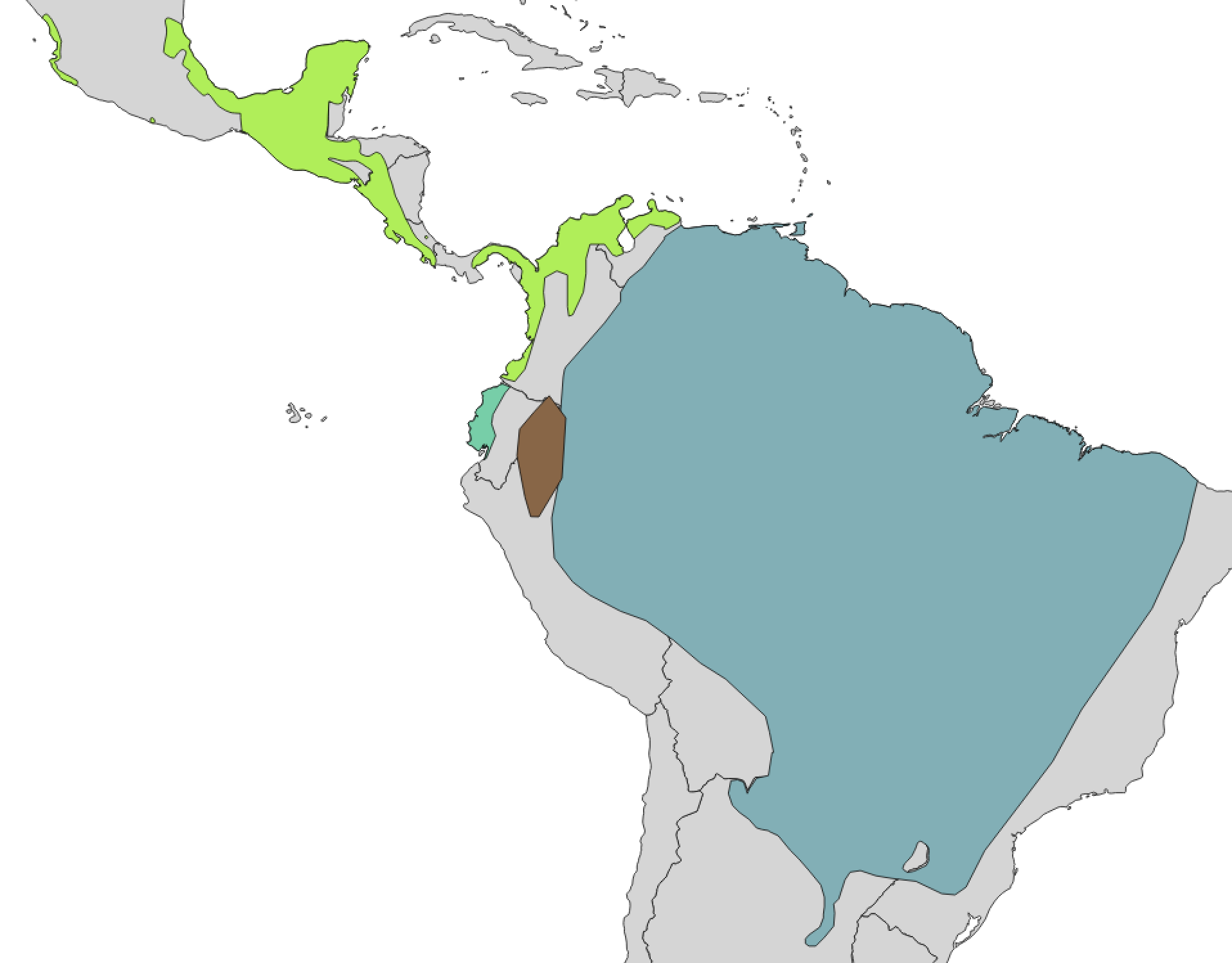
@cisnerosheredia @vechocho @alexpacheco @magazhu @luis_diaz-gamboa @faunamaya @hubertszcz @pedro_nahuat @silviolamothe @johngsalamander @diogoprov @eligarciapadilla
(a) should we follow through with this split
(b) do the ranges look ok to you?
I would support the split. The authors use multiple data types, including both nuclear and mtDNA to make the split, which is generally my criteria.
Your map looks accurate based on their description, but it would have been nice if the authors had done it in their paper. When I review works such as these I always suggest the inclusion of maps. I imagine there is more going on in the Choco as they say in the paper, but they do not address it so you don't need to either (yet).
Hi @loarie , I consider that this map has some omissions in terms of occurrence records, I advise instead of using the IUCN range distribution, download the occurrence records from the digital repositories, GBIF (https://www.gbif.org/) and VertNet (http://vertnet.org/) and merge these records to make a more suitable distribution range map.
For example T. "vermiculatus" have occurrence records in Belize and in the center of Mexico.
Hi luis_diaz-gamboa - I hear what you're saying, but the main purpose of the range maps on iNaturalist is to help people understand what we mean by a taxon (e.g. 'oh you mean Trachycephalus typhonius sensu stricto vs Trachycephalus typhonius sensu lato') and to help us make atlases to properly migrate content following taxon splits like the one proposed here. The image above is the IUCN map just carved up into 4 pieces. Trying to improve the iUCN range map (beyond narrowing it to reflect the narrowed concept) is beyond the scope for me and a bit of a slippery slope. My preference would be that we address the omission problem by adding new records (anyone sitting on a T. vermiculatus photo from Belize or planning a hike there soon?).
If you want to take on making a better range map though it would be welcome if you wanted to share it here, but I don't consider a carved up IUCN map to be a blocker for moving forward with a split.
I totally support the taxon split. This is something that has been thought about for quite some time, since the former T. typhonius was a such wide ranging species. The paper has strong evidence from multiple lines.
Hi @loarie , I understand the limitations of the map, and that it is only to illustrate the possible geographic differences. I agree that the taxon split according to what has been mentioned in the paper and ASW.
thanks luis_diaz-gamboa , diogoprov and johngsalamander for your feedback and thoughts. Sounds like there's broad support for this split so I'll draft it
OK spit committed https://www.inaturalist.org/taxon_changes/84665 will take a while to update all the records


Indeed this species needs to be added. https://www.inaturalist.org/observations/41925493