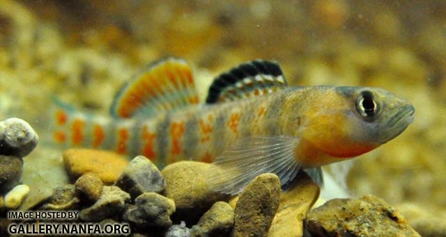
Etheostoma lawrencei
Summary 2
The headwater darter, Etheostoma lawrencei, is found in the upper Green River system down to the Mud River, Kentucky, and in the Cumberland River and upper Salt River systems. It is one of the 324 fish species found in Tennessee.
Diagnostic description 3
Differs from all members of the Etheostoma spectabile complex except E. tecumsehi in having orange belly color confluent with the anterior orange interspaces in breeding males and in having the alternating orange and blue transverse bars prominent along the entire length of the body (versus limited to posterior half) (Ref. 47261).
Distribution 4
Global Range: (5000-20,000 square km (about 2000-8000 square miles)) Range includes the upper Green River system down to Mud River, Kentucky; middle Cumberland River system, from Cumberland Falls, Kentucky, to Dillard Creek, Tennessee (including lower tributaries of Caney Fork); and upper Salt River system, Kentucky (Ceas and Burr 2002, Page and Burr 2011).
Headwaters of the Salt River system; upper Green River system, including the Nolin River; and the Cumberland River system from Wilburn Creek on the north and Dillard Creek on the south side of the Cumberland River, Smith County, Tennessee, upstream to near Cumberland Falls (Ceas 1997). Isolated populations have been found in Round Lick Creek, Wilson-Smith counties, Tennessee, and Rock Springs Branch and Mine Lick Creek, two tributaries of the lower Caney Fork River, Putnam County, Tennessee (Ceas 1997).
Extent of occurrence is roughly 10,000 square kilometers.
Habitat and ecology 5
Habitat and Ecology
Systems
- Freshwater
Iucn red list assessment 6
Red List Category
Red List Criteria
Version
Year Assessed
Assessor/s
Reviewer/s
Contributor/s
Justification
Morphology 7
Dorsal spines (total): 8 - 11; Dorsal soft rays (total): 11 - 15; Analspines: 0; Analsoft rays: 6 - 9
Nature serve conservation status 8
Rounded Global Status Rank: G5 - Secure
Reasons: Common to abundant in suitable habitat in Tennesse and Kentucky.
Range description 9
This species' range includes the upper Green River system down to Mud River, Kentucky; middle Cumberland River system, from Cumberland Falls, Kentucky, to Dillard Creek, Tennessee (including lower tributaries of Caney Fork); and upper Salt River system, Kentucky (Ceas and Burr 2002, Page and Burr 2011).
Headwaters of the Salt River system; upper Green River system, including the Nolin River; and the Cumberland River system from Wilburn Creek on the north and Dillard Creek on the south side of the Cumberland River, Smith County, Tennessee, upstream to near Cumberland Falls (Ceas 1997). Isolated populations have been found in Round Lick Creek, Wilson-Smith counties, Tennessee, and Rock Springs Branch and Mine Lick Creek, two tributaries of the lower Caney Fork River, Putnam County, Tennessee (Ceas 1997).
Extent of occurrence is roughly 10,000 square kilometers.
Sources and Credits
- (c) rkkessler, all rights reserved
- Adapted by rkkessler from a work by (c) Wikipedia, some rights reserved (CC BY-SA), http://en.wikipedia.org/wiki/Etheostoma_lawrencei
- (c) FishBase, some rights reserved (CC BY-NC), http://eol.org/data_objects/20964646
- (c) NatureServe, some rights reserved (CC BY-NC), http://eol.org/data_objects/28805667
- (c) International Union for Conservation of Nature and Natural Resources, some rights reserved (CC BY-NC-SA), http://eol.org/data_objects/34452937
- (c) International Union for Conservation of Nature and Natural Resources, some rights reserved (CC BY-NC-SA), http://eol.org/data_objects/34452934
- (c) FishBase, some rights reserved (CC BY-NC), http://eol.org/data_objects/20964647
- (c) NatureServe, some rights reserved (CC BY-NC), http://eol.org/data_objects/28805660
- (c) International Union for Conservation of Nature and Natural Resources, some rights reserved (CC BY-NC-SA), http://eol.org/data_objects/34452935


