SAVANNA
Savanna
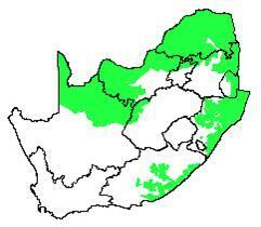
The Savanna is the largest Biome in southern Africa, occupying 46% of its area, and over one-third the area of South Africa. It is well developed over the Lowveld and Kalahari region of South Africa and is also the dominant vegetation in Botswana, Namibia and Zimbabwe.
It is characterized by a grassy ground layer and a distinct upper layer of woody plants. Where this upper layer is near the ground the vegetation may be referred to as Shrubveld, where it is dense as Woodland, and the intermediate stages are locally known as Bushveld.
The environmental factors delimiting the biome are complex: altitude ranges from sea level to 2 000 m; rainfall varies from 235 to 1 000 mm per year; frost may occur from 0 to 120 days per year; and almost every major geological and soil type occurs within the biome. A major factor delimiting the biome is the lack of sufficient rainfall which prevents the upper layer from dominating, coupled with fires and grazing, which keep the grass layer dominant. Summer rainfall is essential for the grass dominance, which, with its fine material, fuels near-annual fires. In fact, almost all species are adapted to survive fires, usually with less than 10% of plants, both in the grass and tree layer, killed by fire. Even with severe burning, most species can resprout from the stem bases.
The grass layer is dominated by C4-type grasses, which are at an advantage where the growing season is hot, but where rainfall has a stronger winter component, C3-type grasses dominate.
The shrub-tree layer may vary from 1 to 20 m in height, but in Bushveld typically varies from 3 to 7 m. The shrub-tree element may come to dominate the vegetation in areas which are being overgrazed.
Most of the savanna vegetation types are used for grazing, mainly by cattle or game. In the southernmost savanna types, goats are the major stock. In some types crops and subtropical fruit are cultivated. Urbanization is not a problem, perhaps because the hot, moist climate and diseases (sleeping sickness, malaria) hindered urban development.
Conservation of savanna is good in principle, mainly due to the presence of the Kruger and Kalahari Gemsbok National Parks within the biome. Similarly, in neighbouring countries, large reserves occur, such as Etosha, Gemsbok, Chobe and Hwange National Parks and the Central Kalahari Game Reserve. However, this high area conserved in South Africa, belies the fact that half of savanna vegetation types are inadequately conserved, in having less than 5% of their area in reserves. However, much of the area is used for game farming and can thus be considered effectively preserved, provided that sustainable stocking levels are maintained. The importance of tourism and big game hunting in the conservation of the area must not be underestimated.
Savanna has a high richness of mammals and birds, but endemicity is low. This is because whereas the area is large, it is still only a portion of the African savanna to the north.
Source: Low, A.B. & Rebelo, A.(T.) G. 1998. Vegetation of South Africa, Lesotho and. Swaziland, edn 2. Dept of Environmental Affairs and Tourism, Pretoria.


Comments
We distinguish four major types of Savanna in southern Africa:
Savanna: Arid - this is locally known as Kalahari Savanna or Thornveld. It occurs in more arid areas and is associated in our area with the Kalahari sands. (the actual boundary of Arid and Mesic Savanna is mapped differently by different authorities).
Savanna: Moist - this is the bulk of Savannas, occurring on richer soils and wetter areas. This includes the highly productive Mopane Savanna.
Savanna: Miombo - also known Brachystegia Woodland. This occurs on the poorer, acidic soils and is characterized by the dropping of leaves in the dry season - i.e a drought deciduous woodland. It is particularly rich in tree species. A characteristic component are the tree genera Miombo (Brachystegia), Mnondo/Muchesa (Julbernardia) and Mutondo (Isoberlinia). This is a tropical type most common in Zimbabwe, and also in Mozambique. it is common in Angola and Zambia.
Savanna: Koakoveld - This is the semi-arid savanna from northwestern Namibia and southwestern Angola
References:
https://www.geos.ed.ac.uk/homes/cryan/miombo
https://www.researchgate.net/publication/299472232_Plant_species_diversity_in_the_Kaokoveld_Namibia
Dear tonyrebelo. Should there not be a rough demarcation between arid savanna and moist savanna on the map or two maps, one for each. Some people record Eastern Botswana as moist savanna and others as arid savanna. Cannot an annual average rainfall of less than 400mm be a definition of arid savanna. I realise that arid and mesic savanna are mapped differently by different authorities but can there not be consistency within habitats-s-afr. I guess its difficult for those of us who live in the transition zone between the two.
It is not a case off rainfall or drawing boundaries. Technically if it is Thornveld it should be Arid and if it is Broadleaf then it should be Moist (or "Mesic"). It is the communities that determine the type of Savanna, and while rainfall is a reasonable substitute, in the field you should be looking at the tree species composition and not be running around trying to find a rain gauge.
Yes, I need a map for southern Africa for savanna.
The problem with transition zones is just that: they are not one or the other. So if some people call it Arid and some Moist then that just reflects their biases and neither are incorrect (presumably they are exercising their eyes in the field and not blindly following a line on a map back home.
(PS: Do all the maps agree on the 400mm isoline? - is there not some variation on this as well?)
Thanks so much. So it doesnt really matter !
Well it does matter, but there is nothing we can do about it if nature herself is confused. We just have to muddle along to the best of our abilities.
This is a different matter, which has not been cleared up yet for the habitats project and Habitats journal and maps ( at least not for me, who may be very ignorant and missing something). Posters have to decide if their area is Moist Savanna or Arid Savanna. I think these two need separate maps and much clearer definitions. Why not define arid savanna as areas where average annual rainfall is less than 500 mm and Moist savanna, if rainfall is above 500mm. Some posters consider moist savanna to be wetlands like the Okavango area, which is quite damp. If there are two types of savanna for the journal, then why not develop two different maps. Wonder if hardveld savanna and sandveld savanna could be a better choice, but since we have started with arid and moist savanna perhaps it would be better to modify that. Please could we have a clear usable definition of moist and arid savanna written into the journal ( perhaps its there but I have missed it!). Im concerned because I think I live on the border between arid and moist savanna, but that is a very subjective decision I have made. Thanks @tonyrebelo and I know I have bought up this issue before. Just want to be a pain in the neck ! Ive just read the old comments before again and still trying to make sense in my mind. I dont think arid and moist savanna should be determined by whether trees are thornveld acacias or broadleaf. Large areas of quite dry savanna can have Terminalia sericea as a dominant tree and moist savanna can have only thorny acacia trees ! Cant the definition be purely based on rainfall so it is moist or arid and nothing else ? Im really still talking to myself and thinking out loud. Whatever criteria are used to decide if an area is moist or arid savanna, cant there be separe maps for each type of savanna ?
Nature is not confused about average annual rainfall !
Im really concerned about the people who in their mind think Okavango swamps or Makgadikgadi pans is the moist savanna and everywhere else is arid ! Perhaps there should be more written into the journal itself and not in the confusing comments written by people like me. Of course Im only thinking about Botswana, the only place I know !
"Nature is not confused about average annual rainfall !"
Of course it is, even year to year nature cannot agree with itself. And have you plotted a running average of MAP, say 10 or 20 year intervals and see if there is actually such a thing as average annual rainfall? I am willing to bet the line will look like soft spaghetti blowing in the wind.
If plant communities cannot decide, and botanists cannot decide, should we just draw an arbitrary line?
For South Africa it is easy: west of Mafikeng it is Arid Savanna (Thornveld) and east (and north) it is Moist Savanna.
I see Swaziland also has issues and divides the country into an Arid and Moist Savanna, even though it is all Moist.
But perhaps Namibia is the most difficult with Arid Savanna grading to Nama Karoo in the south, and the added complication of Kaoko Savanna in the west.
Thanks ! Sorry I have been a difficult customer. I realise there are graduations ! I was interested in mopane savanna, which seems to have a very sharp well defined boundary in Botswana. It is said it likes alkaline soil. However, it seems to be thriving in the drier parts of Eastern Botswana . toward the tip where Zim SA and Botswana meet which has a quite low rainfall and could be considered arid ! It is absent from nearby wetter areas with soil more often used for arable farming ! Things may be different in Bots compared with SA ! Its all terribly complicated but interesting.
Mopane veld is Moist Savanna. Yes it grows on the richer soils and has the highest carrying capacity of aniimals. (and yes, for it soil is probably more important then rainfall ...). But it is boring!!!!!!!!!!!
Give me any other Savanna veld type any day. Especially the leached sands: far more exciting for diversity (plants, trees, insects, mammals, anything! Everything!), even though poor in biomass.
MOPANE SAVANNA Thanks Tony. This is a great and useful journal about Biomes of Southern Africa and should be a model for individual countries , to emulate. We in Botswana need to make a similar journal , on Botswana Biomes making use of experts in the field and ensuring it is in full agreement with your more extensive journal. I made the mistake of not distinguishing between Mopane tree savanna and Mopane stunted shrub savanna and am looking for a map that gives a rough distribution of both.
Found this interesting ! P17 Whereas areas receiving
less than 450 mm of rain per annum are considered to be the true ecological niche of
mopane (Henning and White, 1974), most mopane woodland is found in the 400-700
mm annual rainfall zones. The mean maximum temperature range of the hottest
months is between 34ºC and 38ºC, and the mean minimum temperature of the coldest
months is between 12ºC and 16ºC. The species is reported to be intolerant of severe
frosts, being restricted by the 5ºC mean daily isotherm for the month of July
(Henning and White, 1974; Timberlake, 1995; Van Voorthuizen, 1976).
From BIOMASS PREDICTION MODELS FOR
COLOPHOSPERMUM MOPANE (MOPANE) IN BOTSWANA PATRICK SILISHEBO MUTAKELA
https://core.ac.uk/download/pdf/37321073.pdf
Good mophane ( Setswana spelling !) map on P17 and 19 guess I would need permission to use these maps in a journal or redraw like yours.
Biomes of Botswana wont be made in a day, though I wonder if an expert should do it. But a start should be made.
Biome level is quite simple - less than 10 types: vegetation types and communities are far more complicated, but Botswana and Namibia are probably two of the most easy regions south of the Sahara to map?
I forgot: did we not deal with all this already at: https://www.inaturalist.org/posts/14181-vegetation-associations-in-botswana#activity_comment_2450795
Pyric tussock savannas !!!
@tonyrebelo Thanks so much for the comments above 5 years ago. To me sandveld and hardveld are so interesting with vastly different floras in Botswana and therefore insect life.
Ive just found this document wiith quite a different nomenclature for the type of savannah found in Botswana
IUCN Global Ecosystem Typology 2.0
https://portals.iucn.org/library/node/49250
Page 77 ' Pyric tussock savannas' ! thats a new one
Is this document going to provide the defining nomenclature for other future 'habitats' projects in different regions of Africa ?
Remember that this is the Highest Level classification - at Biome level.
At finer scales there are all sorts of fun possibilties _ for South Africa over 100 types.
Pyric tussock savannas - burning grass savanna - not really a new concept!
If you want a translation:
76: T4.1 Trophic savannas == African Bushveld - dominated by grazers
77: T4.2 Pyric tussock savannas == African Savanna (including our Arid Savanna) - dominated by fires
78 T4.3 Hummock savannas (Australia only)
79 T4.5 Temperate subhumid grasslands = African Grassveld
Add a Comment